Subscribe to our newsletter and keep up to date with urbirun news, new destinations and exclusive routes.
Join de urbirun newsletterStage 3 – Wattwil-Pfäffikon – 36.6km (total 89,45) / 754D+ (2'382) – 8 bridges (19)
The one where I made a detour to run through an additional swiss canton and crossed a lake…
All you want to know about the swiss.crossing Lake2Lake adventure, is here.
I start at 8:40 am, again under a bright blue sky. I am happy because from the first steps, I don’t feel any particular fatigue in my legs…
This is a good thing, because it starts directly and seriously, with a steep ascent in the forest to the castle of Iburg, whose tower with its upper balcony painted with yellow and black patterns dominates the city of Wattwil.
The path then continues up, alternating between meadows and some short portions of forest, always in a landscape as bucolic as yesterday’s. The farms are more frequent than yesterday, and some of them have beautifully painted facades, which is typical of the region. In front of one of them, an old bearded man, almost the spitting image of Heidi’s grandfather, greets me cheerfully. The cliché, in the middle of the postcard.
In spite of the climb, on the first 7 kilometers, the legs are fine.
Then it goes down again, in the meadows, with on my left a magnificent view away on the Alps. Shortly after the small village of Walde (no drinking fountain…), in a descent, I see for the first time the lake of Zurich.
The panorama is very clear, and extends on the left from the plain of Schmerikon and Uznach, then it’s the Obersee, eastern part of the lake of Zurich, then the kind of peninsula that allows to cross the lake, and that I’m going to use to join my destination, that I see on the other bank, then on the right, the main part of the lake. And all this with the snowy peaks of the Glarner, Uri and Schwyz Alps in the background.
I take a short break to refuel in Sankt-Gallenkappel, which I leave by passing a beautiful covered bridge over a gorge whose name I don’t know. I then arrive in the village of Eschenbach after 18km, tempted by a break, but it’s a bit early, and I really want to have the bulk of the “work” behind me when I eat.
I take advantage of the presence of a Migros to buy a picnic, to avoid the risk I took yesterday, where 3 minutes later I would have in front of a store with closed doors, with nothing in the bag and nothing on the horizon…
So, with my picnic, I continue, and I briefly leave the Via 4, to make a detour that leads me to the canton of Zurich, so that I add a canton to my list. So as not to have made the detour for nothing, I stop there to have a picnic after 25 km, sitting on the loading dock of the very small milk collection house in the Moos area.
I’m happy to take this break, I’m starting to be a bit tired, and I also tell myself that every km done is not in front of me.
I start again after a little less than an hour break, but it is rather harsch. Fortunately it starts flat, and that helps me a bit to get back into it. I make a small involuntary detour around the Moosriet marshes, I bypass Jona, then I enter Rapperswil through the residential areas.
I then arrive in the old town, where I run up a nice street, which leads me to the castle. Founded around 1200, this small town was located at the intersection of the Zurich-Chur road and the pilgrims’ route from Germany to Einsiedeln, and the town developed with the transhipment of goods and the collection of tolls.
The castle dates from the beginning of the 13th century. It is built on a small hill, surrounded by the lake of Zürich on 3 sides. The castle was thus well protected and controlled the waterway, as well as the medieval route of the St. Gotthard pass between Lombardy and Zurich, and the path to Compostela in direction of the Einsiedeln Abbey (way I will follow again in the next stage).
The highest tower is the keep (Gügeliturm), from which the “watchman from above” warned the inhabitants of approaching dangers or fires. The pentagonal clock tower has three bells as well as a sundial and two clocks.
I enter the park of the castle, that advances on a kind of promontory which offers a superb panorama on the lake of Zurich.
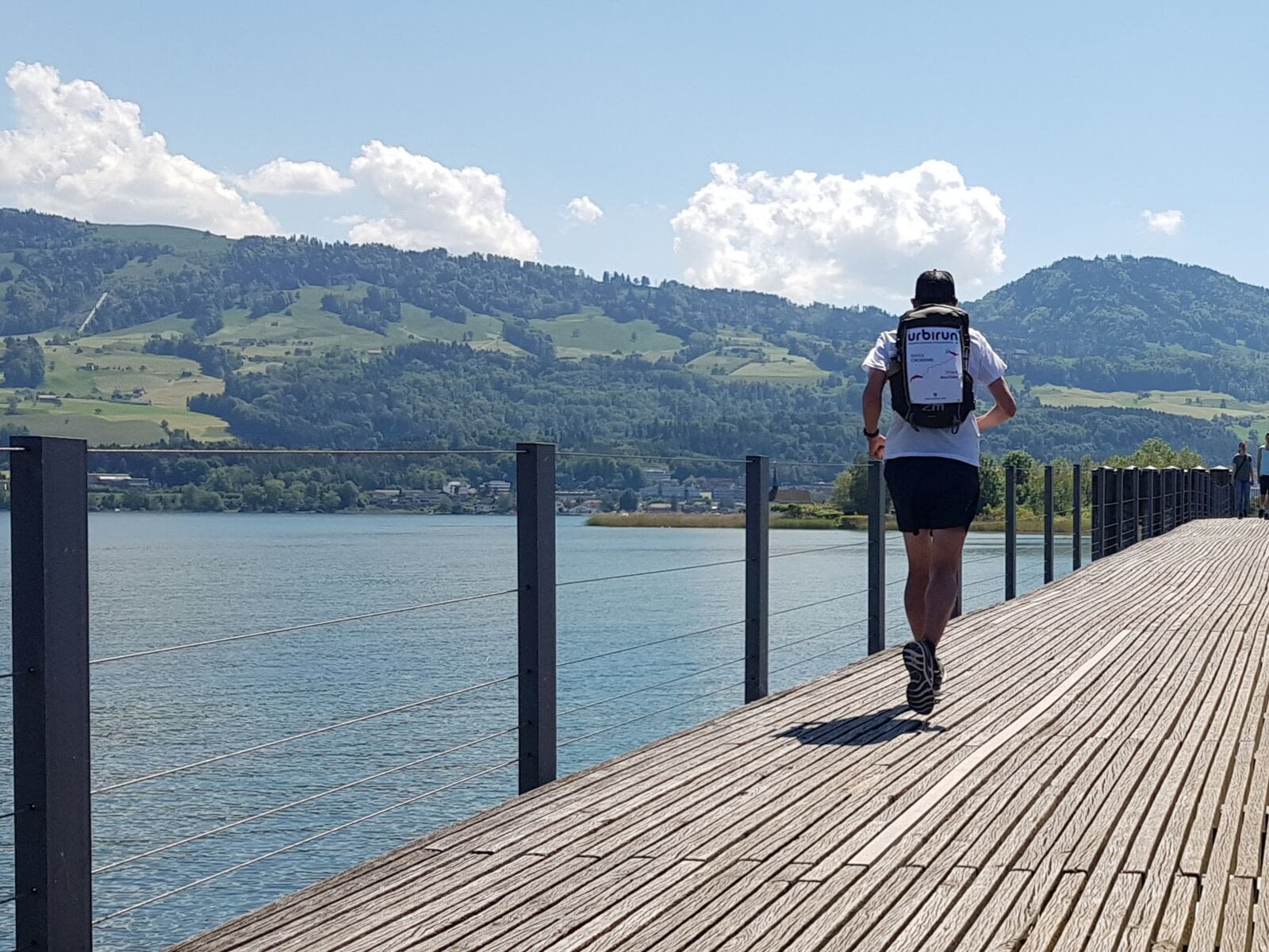
This gives me some energy back, although I have already run 30 km. I see the small chain of islands, connected by wooden bridges, which will allow me to cross the lake and reach Pfäffikon that I can see on the other side.
So I tackle these last km on the wooden footbridges, above the water, which is really not deep. Fish and ducks accompany my run, and I’m surprised at how many pleasure boats there are on the lake for a weekday afternoon.
The crossing is a little more than 3 km long, it’s certainly flat, but I’m starting to be quite tired, it’s hot and I’m thirsty.
Arrived in Pfäffikon, I buy some food, and I run up to the farm where I will be staying tonight. This last climb, in the middle of recent residential buildings, is really a pain in the ass… in fact I think I’m just tired…
I finally arrive, after 36.6km and 754m of ascent, 3 cantons and a lake crossing… and I throw myself on my powerade bottle…
I settle down at the Lützelhof farm, in a small room with a view on the lake. I eat a few, then shower and wash. And finally, it seems to me that I’m not too tired. Maybe I just needed a break… And the terrace is perfect for it… and as far as tiredness is concerned, in fact it is ok.
I order then some pasta that I eat in the room, as I don’t feel like going back to the city…
Lodging : Luetzelhof farm, Dillier family
Previous stage 2/12 Next stage 4/12

